100th Anniversary of Sierra Club Outings Program
Location
John Muir Wilderness, Inyo National Forest, Inyo and Fresno Counties. Maps: Mount Tom, Mount Hilgard (USGS 7.5 Minute Series Topographic). Also USFS Inyo National Forest.
Monday, 13 August 2001 (Pine Creek Trailhead to Honeymoon Lake)
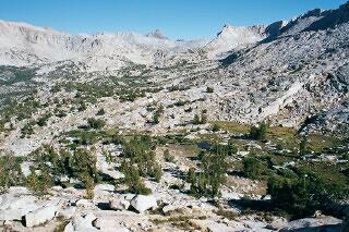
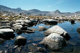
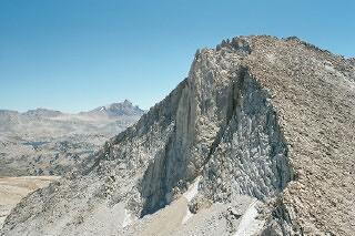
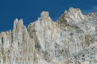
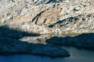
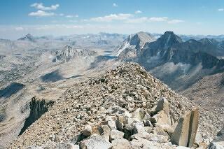
Granite Park Looking Southeast
Met at Pine Creek Trailhead at 0700. Departed at 0815 after introductions, pack weigh-in, transfer of food to packer (Pine Creek Pack Station). Thirteen guests plus Jim and Don. Clear, comfortable morning temperature. Lunch at Lower Pine Lake 1200-1300. Arrived at camp on southeast bluff above Honeymoon Lake about 1415.
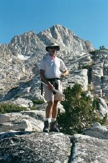
Bob on Survey of Granite Park
After setting up tent and organizing commissary, went on a hike at 1545 with Bob Hammond toward saddle to Royce Lake #4 and then looped around into Granite Park for view of Italy Pass. Reached first small lake along trail in Granite Park at elevation 11,200. We saw a few purple gentians and some white gentians as well as Owl's Clover but generally wildflowers were well past their annual bloom in the high country.
Returned to camp at 1800. German Potato Salad dinner was a bit much for first day appetites. Also had a complete leftover cheesecake dessert. Consider swapping with Day 2 Ramen and chicken meal when appetites will be bigger. Fly fished south shore after dinner with #14 mosquito. Caught and released one small brookie and one slightly larger rainbow (about 7 inches). Saw a nice shooting star traveling east to west with residual trail at 2135 from bed.
Tuesday, 14 August 2001 (Layover Day)
Walked around Honeymoon Lake starting at 0645. Saw Ouzel jumping from rock to rock below outlet of lake. Fished north and west beaches. Caught and released a nice, brightly red-colored brookie on #14 mosquito when it jumped out of water to take the dry fly. Full bodied, about 9 ½ inches.
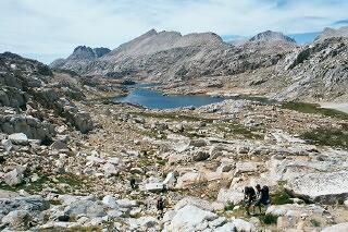
Approaching Chalfant Lakes
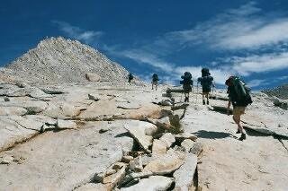
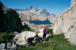
Jim led compass class 0900-0940. Departed for Chalfant Lakes at 1000 with Jim and most of the group. Jim and Pam Bradley and Rebecca headed for saddle to Royce Lakes and potential climb of "Treasure" peak. Followed Italy Pass trail to about 10,800 foot contour, then went cross-country to Chalfant Lakes basin, arriving at uppermost lake at 1200 for lunch.
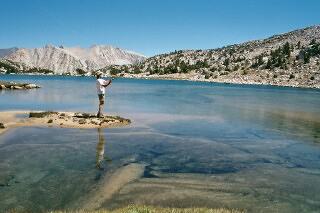
Ira Casting at Inlet of Upper Chalfant Lake
Caught and released a very pale 8 inch golden on #14 brown elk hair caddis immediately on arriving at the lunch spot along northern shore of lake. Fished until 1330, having caught and released about a dozen goldens, rainbows, and one hybrid. Largest golden was 10 ½ - 11 inches, very healthy tone but relatively pale in color relative to typical goldens. Cast once at second highest lake and caught a 7+ inch golden/rainbow hybrid.
Left second lake at 1500, hiking cross-country down the Chalfant drainage to cliffs at northwest corner of Honeymoon Lake. Arrived at camp at 1605. Took a "hot" shower and shaved. Jim (Bradley), Pam, and Rebecca returned shortly before 1700. Rebecca had symptoms of Acute Mountain Sickness. She felt somewhat better after resting in sleeping bag until 1800. Todd and Mary returned at 1730 after hiking up in Granite Park. Ramen dinner went fast with no leftovers. Campfire at 2000. Songs - Manchester Rambler, Seven Old Ladies. Don read cowboy poem "The Spotted Ass". To bed at 1000.
Wednesday, 15 August 2001 (Honeymoon Lake to Merriam Meadow via Pine Creek Pass)

Honeymoon Lake at Sunrise
Awoke at 0410. Saw a bright Perseid meteorite going north to south at 0411. Another East to West at 0421. Total of four seen in ten minutes. During early morning walk after sunrise, encountered a falcon-sized raptor on small bluff across outlet from camp. Had a distinctively white and dark barred tail that was apparent when the bird flew away. Possibly a Northern Goshawk.
Broke camp and started on trail at 0855, Don leading. We changed itinerary from counterclockwise (over Italy Pass) to clockwise (over Pine Creek Pass). First rest at 0935 for water. Reached Pine Creek Pass at 1000. Cirrus clouds moved in from west although "summit" pond immediately north of pass was still sunny.
Summit Tarn, Pine Creek Pass
Had lunch from 1200-1305 in French Canyon where outlet creek from Royce Lakes crosses trail. Reconnaissance of old packer trail to Merriam 1330-1345. Calibrated start point with Jim's GPS. Reached top of Merriam Meadow outlet at 1500 and moved to campsite immediately south of main creek out of Merriam Lake as it reaches Merriam Meadow. Very low water throughout the meadow.
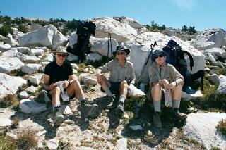
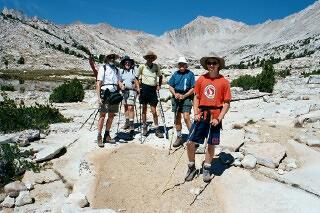
Joe, Jim, and Pam Take a Gorp Break at the Pass
Hiked solo to Merriam Lake 1645-1715. Fished inlet area but did not see any trout. Also cast from east shore - saw one series of cruiser ripples and one light strike before heading back to camp. Arrived camp and dinner at 1830. Rebecca noted she felt much better today. Got to sample first batch of ham and potatoes, a tough preparation meal for Cook Crew C, which worked until nearly dark at the griddle plus cooking down the cake crust for apple cobbler (recommend rethinking this dessert from Backpacker Pantry - too many pots required in conjunction with ham and potatoes main course.
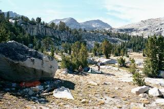
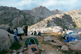
Merriam Meadow Campsite
Small campfire and short conversation period 2030-2100. Woke up at 0010 and 0330 with mild headache and stuffy, dry nose but experienced no further symptoms for rest of the trip. Short, bright Perseid at 0330 moving East to West. Weird fishing dreams - hand catching salmon as they swam through streets of a town, Orange County fishing/golf lake where rod, flies, hat, vest, license were taken. Too much fish on the brain?
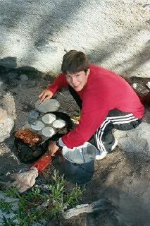
Elise Cooking Up Some Hotcakes
Thursday, 16 August 2001 (Layover Day)
Up at 0700 for pancake breakfast. Another cloudless sunrise. Departed for Royce Peak at 1005, leading second part of climbing group (first contingent started hiking at 0930). Reached lake at base of Royce-Merriam saddle at 1115. Guy and Charles headed back toward camp at this point. Had partial lunch break at east end of lake at 1200.
Merriam Peak from Ridge of Royce Peak
Reached saddle and first group at 1230. Headed for peak via south ridge about 1245 and reached top at 1340. Generally a sandy climb. Encountered a few Sky Pilot flowers in protected areas of soil at base of some of the rocks. All ten climbers summited - Bob, Joe (first Sierra peak), Todd, Mary, Steve, Ted, Jim B., Pam, Rebecca, and Don (fourth ascent going back to mid-1970s). Peak elevation is 13,253 feet.
Started back down at 1500 after completing summit photos. Don's camera balked but others captured ample number of documentary images. Subsequently determined that loose battery retaining flap was the culprit and camera worked ok after descent through rest of the trip. Returned via loop through La Salle Lake to Merriam Lake drainage. Very dry, very low water everywhere. Many portions of lake fringes were exposed and we were able to walk "on the lakes" and avoid wear and tear on meadow edges.
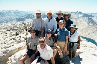
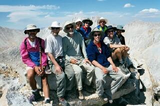
Royce Peak Summit Group
Reached camp at 1740. Glorious (to quote John Muir) hike and day. Showered and shaved in last sun across meadow to south of camp. Another small campfire at 1940 with songs until about 2015 with contributions from Jim G. on harmonica and Charles, Rebecca, Bob, Ira, Elise, and Don as vocalists. Another great shooting star out of Perseus at 2130.
Friday, 17 August 2001 (Merriam Meadow to Ursa Lake)
On to Feather Col
Another bright erratic shooting star at 0330. 37 degrees at 0530, our coolest morning of the trip. Jim led us out of camp at 0810. Took direct line north over bluffs to La Salle Lake. Climbed above the lake to Feather Col via the leftmost (and smaller) of two cracks at eastern end of the lake.
Nice photo ops of our party walking on slabs in relatively early morning light with Feather Peak in the near distance. Saw a large, dark bird (golden eagle?) soaring to and across ridge between Merriam Meadow and us. Arrived at col at 1200 and lunched until 1300. View to south featured an unusual horizontal rainbow effect in sparse cirrus clouds, similar to sun dogs. Elevation 12,400 feet.
Rainbow-colored Halo from Feather Col
Took an hour to descend north side of col to relatively open cross-country hiking. Small snowfield at bottom of first pitch exhibited rapid melting and many gurgling streamlets. Arrived at outlet of Ursa Lake at 1530. Jim and Don scouted for campsite as far as Little Bear Lake but our rest spot on Ursa turned out to be the most attractive option.
Feather Peak North Ridge
On our survey hike, we walked up to within five feet of four white-tailed ptarmigan (an introduced, non-native species) that appeared to be feeding on grasses along one of dry tributaries feeding Big Bear Lake. On return from hike, the group moved to set up camp on bluff above west end of Ursa Lake.
Great site, spectacular late afternoon lighting on Feather Peak, Royce, and other ridges as well as foreground boulders and ledges to East. No trees of any kind were in sight. Caught a small golden (~8 inches) below bluffs of camp on brown #14 caddis. This camp has reasonable access to water at the lake outlet. Discussed with Jim that for spectacular views this site rated in top five of all time.
Approaching Bear Paw Lake
After dinner, Don pointed out selected constellations to Bob and Elise. Consulted Don's planisphere to identify small kite-shaped Delphinus (the dolphin). Also viewed Perseus double cluster, Andromeda galaxy, and open clusters in Scorpius. Summer triangle of Deneb (Cygnus), Vega (Lyra), and Altair (Aquila) were prominent again as they had been all week.
Campsite at Ursa Lake
Finally turned in at 2100 but scanned sky from bed with binoculars until 2200. Great star clouds throughout the Milky Way that stretched from horizon-to-horizon northeast-to-southwest and passing directly overhead.
Saturday, 18 August 2001 (Layover Day)
Awoke at 0330. About 10 bright shooting stars (~ 15 total, including faint ones) seen 0340-0400 including three in one 30 second span. Many went across Pleiades toward Cassiopeia. A few are still originating from Perseus even thought peak of the Perseid shower was nearly a week ago (morning of 12 August, when earth passed through portion of its orbit that coincides with crossing point of Comet Swift-Tuttle). Nice binocular views of Andromeda Galaxy, Pleiades, and Orion Nebula.
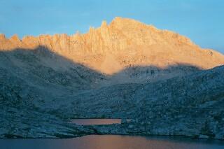
Sunset on Feather Peak
Up at 0700 and went up on ridge to photograph Seven Gables Peak in early light. Fished inlet of Big Bear Lake. Many strikes on #14 brown caddis, with four hookups and runs and two releases. Kept one 10-incher for breakfast sampler (one fish not released during the trip). Brilliant colors were characteristic for a pure Volcano Creek golden, perhaps the most beautiful of all trout species. Flesh was pink, indicative of feeding on crustaceans. Shared bite-sized samples with trip members.
Big Bear Lake in Early Morning Light
Left at 1010 with Jim for "ramble" to Black Bear Lake. Arrived lake outlet about 1045 after stops to views and photos back toward Seven Gables. Encountered dozens of black tadpoles, some nearly mature with complete hind legs, in lakelet below Black Bear outlet. No rises or strikes as Jim and I cast around lake counterclockwise from outlet. Did see an 11-12 inch golden cruise out into the lake from a hiding spot under a rock near shore.
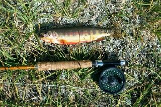
Volcano Creek Golden Trout from Big Bear Lake
Todd dove in from boulders along western shore for two swims toward middle of the lake. Jim took photo of me casting from southeast inlet beach peninsula - a particularly scenic spot in spite of wind. Lunched at east end of the lake between 1200 and 1300. Saw cat prints about 2" diameter near northeast inlet beach. Probably bobcat. Small birds, probably one of the native sparrow species, were feeding in the "surf zone".
Jim on Hike up from Big Bear Lake to Black Bear Lake
We continued around north shore and then hiked up along brook feeding Black Bear from the Northwest, toward White Bear Lake. There were pockets carpeted with yellow monkey flowers (Mimulus family) on diminutive stalks all along the way to White Bear. This log entry is being made from one of these little oases. Turning around, we have a panoramic view encompassing Black Bear Lake, the rim of peaks to the east, Feather Peak and Col, and the adjoining peak just west of the col. Around to the right (West) is Gemini with its twin peaks and protected snow field.
Monkey Flowers above Black Bear Lake
I took a necessarily quick dip in second pond above Black Bear Lake. It was extraordinarily cold. Caught up with Jim on bluffs above White Bear Lake. Walked down to a beach on east end and jumped in for a BRACING "swim" of about 25 feet total length each way. Lake is at 11,900 feet and the deceptively warm surface water at the beach must have been about two inches thick. Snow bank in shade along southern bluffs should have been an early warning. Jim requested I swim back out for a photo.
Thoroughly frozen (make that refreshed), I dried off and dressed and we hiked to look over into the basin containing Brown Bear Lake, the Hilgard Branch of Bear Creek, and Mount Hilgard and Mount Gabb in the northern distance. This note is now being written on descent to Big Bear Lake on the route we will take tomorrow morning. Saw a pair of wrens about 2/3's of the way down to Big Bear. The were actively chirping at each other but not singing their lovely songs.
Returned to camp shortly before 1600. Bob had returned shortly before us and mentioned having very good luck with caddis flies on east end of Big Bear Lake until noon when things quieted down (and the wind increased). Jim Bradley returned at 1630 having climbed three peaks on the ridge north and east of Black Bear Lake. I shaved and showered before dinner. Caught a 9+ inch mostly golden hybrid (with a few extra spots forward) below camp bluff in couple of minutes before soup was served. We turned in early, with everyone in bed by 2100.
Sunday, 19 August 2001 (Ursa Lake to Granite Park via "Dancing Bear" and Italy Passes)
Saw ten bright shooting stars between 0220 and 0240, mostly directly overhead in vicinity of Cassiopeia. Awakened again by Jim's bird song at 0600. Jim and others mentioned hearing ptarmigan in camp "cooing" at 0530. After packing up and before breakfast, I hiked back to location we had seen them the first afternoon and was treated with a close up encounter with a pika in the same spot. From about six feet, we exchanged investigative looks through my binoculars. I did not realize they had such long or so many whiskers. Headed back to breakfast after he finally dashed down below the rock from which he was checking me out.
Broke camp at 0840 with Don leading for the day. Reached west end of White Bear Lake at 0920 for a water break. Took a small side trip north of the lake to show everyone Brown Bear Lake and Mount Hilgard. Slogged up the very sandy Dancing Bear Pass (so named by Jim from a previous trip here). Reached top of the west end of the pass at 1000 and the east end by 1010 following very flat terrain, especially so since we were able to walk across the bottoms of the dry tarns. Crossed the first snowfield to maintain elevation but should have gone down and around for a safer route. Snow was slightly icy and Pam lost her footing but did not slide. Fortunately she was able to recover.
Julius Caesar Summit Ridge Looking South
I found occasional ducks to indicate where others had navigated through the talus en route to Italy Pass, particularly in the first portion between the snowfield and about half way to the pass. Was able to hold elevation and contour to the pass at elevation 12,400+ feet, arriving at 1213. Saw our first puffy clouds in days - since French Canyon. Strong winds were blowing through the pass from the north so we moved to a relatively sheltered area on south side. It became very hot when the swirling winds occasionally subsided. Slight haze (from forest fires?) but we were still able to see peaks two to three times the distance of Mount Humphreys to the south, possibly seeing North Palisade.
Mount Julius Caesar Summit Group
Departed for Mount Julius Caesar at 1304, Don leading our party of ten. Climbers were Todd, Mary, Ted, Steve, Elise, Ira, Charles, Bob, Jim, and Don. On reaching summit ridge via west slope talus, we met four climbers from Angeles Chapter, Sierra Peaks Section, who were starting to descend. Spoke briefly with Will McWinney (sp?) from this party.
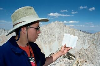
Ted Holding Julius Caesar Register
All ten of us reached the peak's summit blocks by 1415. Took photos of group and the logbook, which only went back to 1997. I originally climbed this peak in April 1972 under snow conditions and noted the difference in appearance now that virtually no snow was visible anywhere in the high country. We started our descent at 1500, reaching the pass at 1550 via a somewhat easier route closer to the southwest ridge.
Jim G. and other four trip members had left the pass earlier to locate a camp. We hope to see them somewhere down in Granite Park in the next 1 ½ to 2 miles. We departed the pass at 1615 in very strong winds from the north. Winds abated quickly though once we were below the pass. Followed the zigzags of trail immediately below the pass area and then went cross-country until picking up stretches of trail.
Although we were tired from the hike from Ursa, the two passes, and the climb, the low afternoon lighting and spectacular scenery of Granite Park made for a pleasant walk. At the first crossing of the stream, saw two goldens dart upstream from their resting place at the downstream end of a pool. Bob noted very large mayfly "spinners" floating on the surface - over an inch long wing-tip to wing-tip. These were the only mayflies we saw on the entire trip. Must have been some pretty well fed trout.
Met up with our group at a site west of the trail at about 11,400-foot elevation at 1750. More extraordinary views to the south from this site, including very nice sunset effects on Mount Humphreys and "Jim's Peak" (aka Treasure Peak). Cream of Spinach Soup and Chicken Montana dinner went quickly and completely with our mountain appetites in full swing. Guy was active in photographically documenting camp.
It was a somewhat cooler evening and I was a little chilled at bedtime, probably due to calories expended during the day. Lights were out at 2100. Shortly before then, some of us watched a very bright satellite traverse from northwest to southeast, then fade. Up until the fadeout, we were debating whether it was a satellite or plane, even though binocular view revealed no flashing red/green lights. [Note: I subsequently learned the International Space Station was transiting at this time.]
Monday, 20 August 2001 (Granite Park to Pine Creek Trailhead)
Saw three meteorites in about 15 minutes, 0145 - 0200. The third one was satisfyingly bright and left a lingering trail while moving north to south across Cassiopeia and Perseus. Also got to view sky at 0440 and saw one shooting star far to the east and another bright one (last of the trip) leave a medium length trail as it radiated from Perseus. Venus, Jupiter, and Saturn were formed up in a straight line from the eastern horizon with Saturn about the twice the distance from Jupiter as Jupiter was from Venus. Saturn, faintest of the three, was immediately above the "V" of the Hyades open cluster in Taurus. Venus was by far the brightest object in the sky.
Wakeup birdcall was an early 0550. After a quick cereal breakfast that polished off almost all of the remaining oatmeal, we gathered to scrub pots and perform a final packing of commissary equipment and the minimal remaining food. Joe mentioned he had finally spotted the Andromeda Galaxy. Left camp at 0850, Jim leading. Arrived via trail at western inlet of Honeymoon Lake at 0900 for group photos of trip members in front of small waterslide.
Continued on down Pine Creek trail where we lunched about 1200 to 1230 at the first water below the Brownstone Mine site (~ 8800 foot elevation). This rest stop provided us running water, shade, and great views of the Pine Creek tungsten mine and mill buildings. Todd and Don polished off seconds and thirds of Ritz Crackers but there were still a couple of tubes left - about the only leftovers of any kind. Arrived at trailhead at 1315. Commissary bags were returned and we agreed to meet back up at Hot Creek later in the afternoon.
Special note. For the first time Jim or I could remember, we had 100% participation for the Hot Creek soaking and for a great Italian dinner at Perry's in Mammoth Lakes. Our group camaraderie and good spirits lasted to the very end. As Jim and I drove back to Jim's home near Tom's Place, we both commented on the quality and spirit of the trip members and agreed it was one of our best National Outings ever. This was certainly our most uniformly strong hiking group.
ReferencesFollowing are selected references from my personal collection relating to things we saw:
For additional background information on the annual Perseid meteor shower, the website www.amsmeteors.org/meteor-showers/major-meteor-showers/ provides an excellent overview.