What is an Interpolater?
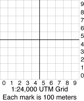
Each UTM grid on a 7.5 minute USGS map is 1000 meters square.
An Interpolater is an overlay which is used to break each grid down into 100 meter squares.
Now that you have 100 meters squares, you can further increase you precision by estimating 10 meter increments in each square.
View and print the Interpolater in PDF format (provided by Steve Bryant of the Riverside Mountain Rescue Unit). Make sure your printer is set to print at 100% size, not reduced or enlarged.
Print it on a transparency then laminate it for strength. Transparency paper for laser jet and ink jet printers and laminate paper that does not require heat are available from Amazon and office supply stores. Thermal lamination may be available from office supply and business service stores.
This Interpolater is intended be used with a 7.5 minute (1:24000) map.