How do I use UTM?
Some instructions never seems to make sense until you actually try to do them. This example is one of those things. Simply reading without trying the exercise may be confusing.
Here are a couple rules you must follow before you attempt to use UTM.
Make sure that everyone is using the same datum. Common datums include NAD27 CONUS, NAD83 and WGS80. Make sure everyone is using the same datum that is marked on your map. To check the datum on a U.S. Geological Survey map, look in the lower-left corner.
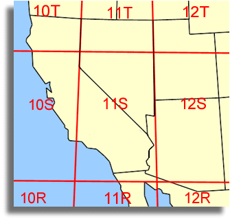
California-Nevada area zone map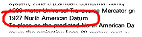
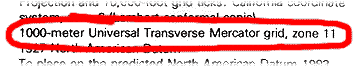
Make sure that everyone is using the correct UTM zone. Otherwise, your position will be about 350 miles off. This is usually not a problem unless someone is using a GPS that was previously used in a different state. Most of the Sierra Nevada is in zone 11S.
For example: in zone 11S, the '11' is the most important part. The 'S' will automatically change when you enter your Northing position.
Now that we are all on the same sheet of music, let's try an exercise:
- Gather your map and interpolator or Metric Coordinate Reader
Mark any position on your map.
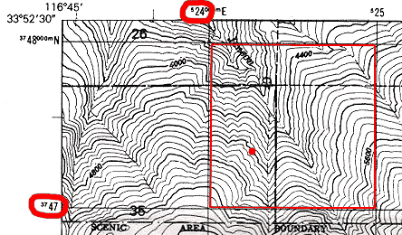
- Note which 1000 meter grid your mark is in. Ours is in 524000, 3747000. Note that the Easting number is always read first, then the Northing. Also note that two digits are large and the rest are small. This makes it easier to read.
Now lay your interpolator or Metric Coordinate Reader over your map.
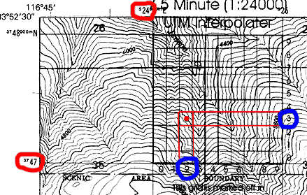
- Note which 100 meter square your mark is in. Add that to your coordinates from step 3. Ours is in 524200, 3747300
- For an little more accuracy, you can estimate the position within the square to the nearest 10 meters. For example: our mark appears to be halfway past the 100 meter markers. The result would be 524250, 3747350.
- Although you probably won't read the entire UTM position, remember that when you are recording your information for later use, it is not complete without the grid and datum. Our final coordinate is 11S 524250, 3747350 NAD27 CONUS. It looks confusing but, as you just learned, it's rather simple.