The TOPO! series of topographic maps on CD/DVD formerly published by the National Geographic Society were an excellent tool for planning trips. Unfortunately, they are no-longer available.
This page illustrates the type of maps that could be prepared for a week long trip in the Bear Lakes area of the Sierra Nevada in California. Don Endicott, assistant leader on this August 2001 Sierra Club National outing prepared these maps.
If you own the California State TOPO! CD/DVD set, you can download this file bearlakestopo.tpo and reproduce the information on your computer. TO DOWNLOAD THIS FILE: RIGHT CLICK on the link and choose "Save target as..." or "Save Link as..." and then choose a location on your computer to save the file. To use the file, open it in TOPO!.
If you open the bearlakestopo.tpo file in TOPO! you will get a map displaying the entire eight day trip.

Note the following information about this map:
TOPO! can also create a profile of the day's hike such as this one for day 1:
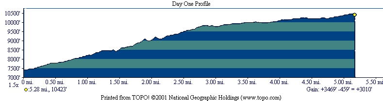
The profile shows that the hike is 5.28 miles long, starts at 7,413 feet elevation, gains 3,469 feet, loses 459 feet for a net gain of 3,010 feet to end at 10,423 feet elevation. In the program you can move the yellow dot shown in the upper right to any position on the route to determine the elevation and distance from the beginning.
The following pages show the map and profile for each day's hike.